


Trail Combe Lavaux Jean Rolland

Fab-Oz
User
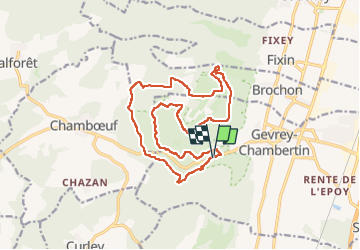

Length
17.5 km

Max alt
524 m

Uphill gradient
379 m
Km-Effort
23 km

Min alt
319 m

Downhill gradient
378 m
Boucle
Yes
Creation date :
2025-08-10 09:27:12.175
Updated on :
2025-08-10 12:32:22.655
2h56
Difficulty : Medium

FREE GPS app for hiking
 SityTrail
IGN / Geographical institutes
SityTrail Plus
The world is yours!
About
Trail Trail of 17.5 km to be discovered at Bourgogne-Franche-Comté, Côte-d'Or, Gevrey-Chambertin. This trail is proposed by Fab-Oz.
Positioning
Country:
France
Region :
Bourgogne-Franche-Comté
Department/Province :
Côte-d'Or
Municipality :
Gevrey-Chambertin
Location:
Unknown
Start:(Dec)
Start:(UTM)
647616 ; 5231749 (31T) N.
Comments