


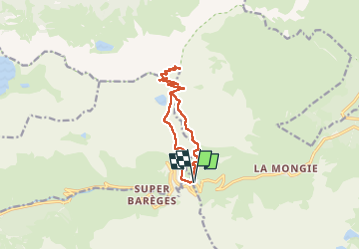
J15-Pic du midi de Bigorre

ETMU5496
User


4h13
Difficulty : Medium

FREE GPS app for hiking
 SityTrail
IGN / Geographical institutes
SityTrail Plus
The world is yours!
About
Trail Walking of 14 km to be discovered at Occitania, Hautespyrenees, Bagnères-de-Bigorre. This trail is proposed by ETMU5496.
Description
Au départ du col du Tourmalet. Semi boucle entre col Tourmalet et col du Sencours. Qqes passages techniques en crête dans la montée. Superbe randonnée
IBP=108
Photos


55 photos in total. Please click on a photo to see them all in the gallery.
Positioning
Comments