


250811 - Tignes - Lavachet-Tovière (prépa)

randodan
User
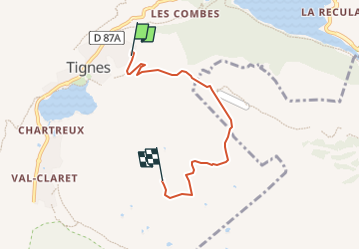

Length
4.6 km

Max alt
2696 m

Uphill gradient
625 m
Km-Effort
10.9 km

Min alt
2069 m

Downhill gradient
9 m
Boucle
No
Creation date :
2025-08-10 13:07:31.21
Updated on :
2025-08-11 15:29:33.004
2h28
Difficulty : Medium

FREE GPS app for hiking
 SityTrail
IGN / Geographical institutes
SityTrail Plus
The world is yours!
About
Trail Walking of 4.6 km to be discovered at Auvergne-Rhône-Alpes, Savoy, Tignes. This trail is proposed by randodan.
Description
Tracé manuel de PREPA
Départ Lavachet, GR5, PasDeTovière, descente par Télécabine Tovière
Positioning
Country:
France
Region :
Auvergne-Rhône-Alpes
Department/Province :
Savoy
Municipality :
Tignes
Location:
Unknown
Start:(Dec)
Start:(UTM)
337034 ; 5037398 (32T) N.
Comments