


le llocheur01

marco14
User
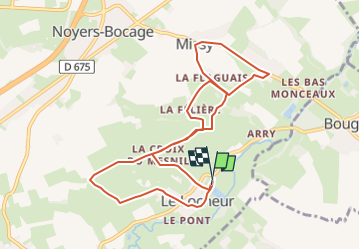

Length
9.5 km

Max alt
122 m

Uphill gradient
142 m
Km-Effort
11.3 km

Min alt
55 m

Downhill gradient
141 m
Boucle
Yes
Creation date :
2025-08-11 07:15:31.845
Updated on :
2025-08-11 14:39:20.71
2h34
Difficulty : Easy
2h34
Difficulty : Medium

FREE GPS app for hiking
 SityTrail
IGN / Geographical institutes
SityTrail Plus
The world is yours!
About
Trail On foot of 9.5 km to be discovered at Normandy, Calvados, Val d'Arry. This trail is proposed by marco14.
Positioning
Country:
France
Region :
Normandy
Department/Province :
Calvados
Municipality :
Val d'Arry
Location:
Le Locheur
Start:(Dec)
Start:(UTM)
678920 ; 5442042 (30U) N.
Comments