


route de Larajasse

bena42
User

Length
71 km

Max alt
896 m

Uphill gradient
1283 m
Km-Effort
88 km

Min alt
488 m

Downhill gradient
1281 m
Boucle
Yes
Creation date :
2025-08-11 04:50:00.705
Updated on :
2025-08-11 09:01:07.501
4h00
Difficulty : Medium

FREE GPS app for hiking
 SityTrail
IGN / Geographical institutes
SityTrail Plus
The world is yours!
About
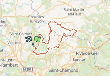
Trail Road bike of 71 km to be discovered at Auvergne-Rhône-Alpes, Loire, Saint-Héand. This trail is proposed by bena42.
Positioning
Country:
France
Region :
Auvergne-Rhône-Alpes
Department/Province :
Loire
Municipality :
Saint-Héand
Location:
Unknown
Start:(Dec)
Start:(UTM)
607277 ; 5045100 (31T) N.
Comments