


20250812 Rando Thomery

TaxiMarne
User
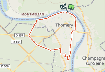

Length
7.4 km

Max alt
109 m

Uphill gradient
95 m
Km-Effort
8.7 km

Min alt
41 m

Downhill gradient
94 m
Boucle
Yes
Creation date :
2025-08-12 07:25:50.89
Updated on :
2025-08-12 09:58:23.646
1h53
Difficulty : Medium

FREE GPS app for hiking
 SityTrail
IGN / Geographical institutes
SityTrail Plus
The world is yours!
About
Trail Walking of 7.4 km to be discovered at Ile-de-France, Seine-et-Marne, Thomery. This trail is proposed by TaxiMarne.
Positioning
Country:
France
Region :
Ile-de-France
Department/Province :
Seine-et-Marne
Municipality :
Thomery
Location:
Unknown
Start:(Dec)
Start:(UTM)
484211 ; 5362291 (31U) N.
Comments