


st cyprien de merde

stef789
User GUIDE
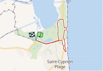

Length
6.6 km

Max alt
8 m

Uphill gradient
21 m
Km-Effort
6.9 km

Min alt
-4 m

Downhill gradient
21 m
Boucle
Yes
Creation date :
2025-08-11 13:13:01.608
Updated on :
2025-08-12 11:22:54.243
2h30
Difficulty : Medium

FREE GPS app for hiking
 SityTrail
IGN / Geographical institutes
SityTrail Plus
The world is yours!
About
Trail Walking of 6.6 km to be discovered at Occitania, Pyrénées-Orientales, Saint-Cyprien. This trail is proposed by stef789.
Description
1500 m le long de la route
1500 m d un chrmon de sable de3m impossible à quitter pour isiter la vraie nature
2500 m entre mer et grand route
retour par la route du depart
A NE PAS FAIRE
Photos


Positioning
Country:
France
Region :
Occitania
Department/Province :
Pyrénées-Orientales
Municipality :
Saint-Cyprien
Location:
Unknown
Start:(Dec)
Start:(UTM)
501380 ; 4720805 (31T) N.
Comments