


Forêt de Carnelle

jpcccb
User
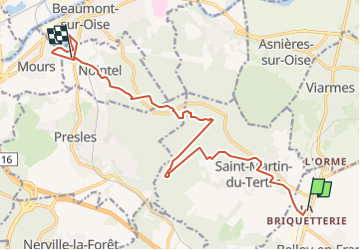

Length
14.2 km

Max alt
207 m

Uphill gradient
202 m
Km-Effort
17.3 km

Min alt
26 m

Downhill gradient
303 m
Boucle
No
Creation date :
2025-08-17 09:51:12.46
Updated on :
2025-08-17 13:10:43.131
3h55
Difficulty : Difficult

FREE GPS app for hiking
 SityTrail
IGN / Geographical institutes
SityTrail Plus
The world is yours!
About
Trail Walking of 14.2 km to be discovered at Ile-de-France, Val-d'Oise, Belloy-en-France. This trail is proposed by jpcccb.
Positioning
Country:
France
Region :
Ile-de-France
Department/Province :
Val-d'Oise
Municipality :
Belloy-en-France
Location:
Unknown
Start:(Dec)
Start:(UTM)
453379 ; 5438561 (31U) N.
Comments