


houlgate

jchezlemas
User
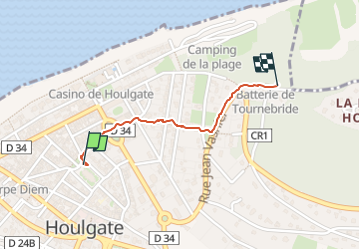

Length
856 m

Max alt
92 m

Uphill gradient
70 m
Km-Effort
1.6 km

Min alt
15 m

Downhill gradient
1 m
Boucle
No
Creation date :
2025-08-18 07:13:39.112
Updated on :
2025-08-18 08:15:18.071
1h01
Difficulty : Easy

FREE GPS app for hiking
 SityTrail
IGN / Geographical institutes
SityTrail Plus
The world is yours!
About
Trail Walking of 856 m to be discovered at Normandy, Calvados, Houlgate. This trail is proposed by jchezlemas.
Positioning
Country:
France
Region :
Normandy
Department/Province :
Calvados
Municipality :
Houlgate
Location:
Unknown
Start:(Dec)
Start:(UTM)
712617 ; 5465215 (30U) N.
Comments