


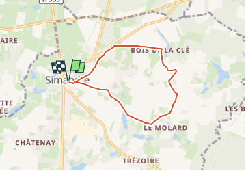
Simandre , les Brulés , les Chevenelles , le bois des Roux et retour par champs des Noyers .

jeanpaulcheyssac
User

Length
6.1 km

Max alt
215 m

Uphill gradient
34 m
Km-Effort
6.5 km

Min alt
199 m

Downhill gradient
34 m
Boucle
Yes
Creation date :
2025-08-21 16:30:48.51
Updated on :
2025-08-21 16:34:13.35
1h29
Difficulty : Easy

FREE GPS app for hiking
 SityTrail
IGN / Geographical institutes
SityTrail Plus
The world is yours!
About
Trail On foot of 6.1 km to be discovered at Bourgogne-Franche-Comté, Saône-et-Loire, Simandre. This trail is proposed by jeanpaulcheyssac.
Description
Départ : Parking salle des fêtes .
Positioning
Country:
France
Region :
Bourgogne-Franche-Comté
Department/Province :
Saône-et-Loire
Municipality :
Simandre
Location:
Unknown
Start:(Dec)
Start:(UTM)
652250 ; 5165317 (31T) N.
Comments