


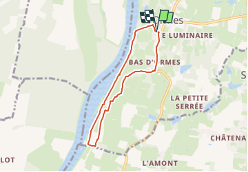
Ormes , bords de Saone jusqu'après le barrage et retour par la tuilerie et le bas d'Ormes .

jeanpaulcheyssac
User

Length
6 km

Max alt
201 m

Uphill gradient
48 m
Km-Effort
6.7 km

Min alt
169 m

Downhill gradient
46 m
Boucle
Yes
Creation date :
2025-08-21 16:49:55.907
Updated on :
2025-08-21 16:52:43.764
1h30
Difficulty : Easy

FREE GPS app for hiking
 SityTrail
IGN / Geographical institutes
SityTrail Plus
The world is yours!
About
Trail On foot of 6 km to be discovered at Bourgogne-Franche-Comté, Saône-et-Loire, Ormes. This trail is proposed by jeanpaulcheyssac.
Description
Départ : Parking autour de l'église et mairie .
Positioning
Country:
France
Region :
Bourgogne-Franche-Comté
Department/Province :
Saône-et-Loire
Municipality :
Ormes
Location:
Unknown
Start:(Dec)
Start:(UTM)
650165 ; 5166134 (31T) N.
Comments