


Bruno 100815 Corrèze

maginot
User
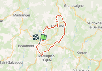

Length
28 km

Max alt
733 m

Uphill gradient
565 m
Km-Effort
36 km

Min alt
520 m

Downhill gradient
566 m
Boucle
Yes
Creation date :
2015-08-11 00:00:00.0
Updated on :
2015-08-11 00:00:00.0
2h21
Difficulty : Medium

FREE GPS app for hiking
 SityTrail
IGN / Geographical institutes
SityTrail Plus
The world is yours!
About
Trail Walking of 28 km to be discovered at New Aquitaine, Corrèze, Saint-Augustin. This trail is proposed by maginot.
Description
Super sortie temps idéal après 2 jours de pluie des odeurs et des paysage magnifique Les chemins sont parfait pour le VTT avec par moment du technique
Positioning
Country:
France
Region :
New Aquitaine
Department/Province :
Corrèze
Municipality :
Saint-Augustin
Location:
Unknown
Start:(Dec)
Start:(UTM)
408909 ; 5030896 (31T) N.
Comments