Trail Walking Saint-Pierre-de-Chartreuse - 
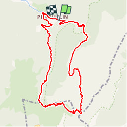
Dent de Crolles depuis Perquelin  - Photo
© OpenStreetMap contributors
Length
Length
12.7 km
Max alt
Max alt
2038 m
Uphill gradient
Uphill gradient
1122 m
Km-Effort
Km-Effort  
28 km
Min alt
Min alt
968 m
Downhill gradient
Downhill gradient
1132 m
Boucle
Boucle
Yes
Creation date :
2015-08-17 00:00:00.0
Updated on :
2015-08-17 00:00:00.0

(1 Reviews)

Walking
Walking
6h19
Difficulty : Difficult

Scan this QR Code to open this trail in the SityTrail application

FREE GPS app for hiking

Logo SityTrail SityTrail

IGN / Geographical institutes

Download SityTrail from the App Store Download SityTrail from Google Play

Logo SityTrail SityTrail Plus

The world is yours!

Download SityTrail from the App Store Download SityTrail from Google Play Download SityTrail on Huawei AppGallery

About

Trail Walking of 12.7 km to be discovered at Auvergne-Rhône-Alpes, Isère, Saint-Pierre-de-Chartreuse. This trail is proposed by patpounet73.

Description

Sentier peu marqué après la source du Guiers. Arrivé vers la cote 1680 m, le sentier, apparent, conduit à une barre rocheuse infranchissable (panneau réserve de chasse). Le sentier, en fait,se situe en haut, tout contre la paroi, un arbre déraciné masque la trace. La distance annoncée est celle de mon GPS qui a pas mal bugué contre la paroi (mauvaise réception des satellites).

Elevation profile

Positioning

Country:
France
Region :
Auvergne-Rhône-Alpes
Department/Province :
Isère
Municipality :
Saint-Pierre-de-Chartreuse
Location:
Unknown
Start:(UTM)
723156 ; 5023668 (31T) N.

Comments

Please log in to post a review or rate the element


Excellent !


Close
My subscriptions