


VTC_160815

d.rognon
User

Length
22 km

Max alt
349 m

Uphill gradient
343 m
Km-Effort
26 km

Min alt
205 m

Downhill gradient
343 m
Boucle
Yes
Creation date :
2015-08-16 00:00:00.0
Updated on :
2015-08-16 00:00:00.0
2h30
Difficulty : Unknown

FREE GPS app for hiking
 SityTrail
IGN / Geographical institutes
SityTrail Plus
The world is yours!
About
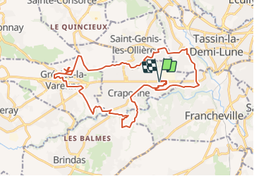
Trail Mountain bike of 22 km to be discovered at Auvergne-Rhône-Alpes, Métropole de Lyon, Craponne. This trail is proposed by d.rognon.
Description
Craponne - Brindas - Grézieu la Varenne -Craponne
Positioning
Country:
France
Region :
Auvergne-Rhône-Alpes
Department/Province :
Métropole de Lyon
Municipality :
Craponne
Location:
Unknown
Start:(Dec)
Start:(UTM)
635208 ; 5067444 (31T) N.
Comments