


Zevtt - Bonnes 2015

kipoura
User
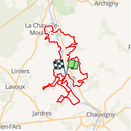

Length
48 km

Max alt
130 m

Uphill gradient
707 m
Km-Effort
57 km

Min alt
52 m

Downhill gradient
709 m
Boucle
Yes
Creation date :
2019-05-03 17:10:00.932
Updated on :
2019-05-03 17:10:01.06
3h41
Difficulty : Medium

FREE GPS app for hiking
 SityTrail
IGN / Geographical institutes
SityTrail Plus
The world is yours!
About
Trail Mountain bike of 48 km to be discovered at New Aquitaine, Vienne, Bonnes. This trail is proposed by kipoura.
Description
Sur les traces de la Juliennoise 2015 ....un parcours au top .... http://zevtt.free.fr
Positioning
Country:
France
Region :
New Aquitaine
Department/Province :
Vienne
Municipality :
Bonnes
Location:
Unknown
Start:(Dec)
Start:(UTM)
315993 ; 5164049 (31T) N.
Comments