


Zevtt - Col des Rochilles

kipoura
User
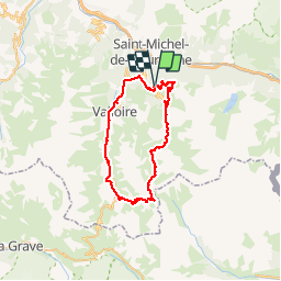

Length
48 km

Max alt
2551 m

Uphill gradient
2258 m
Km-Effort
78 km

Min alt
1385 m

Downhill gradient
2250 m
Boucle
Yes
Creation date :
2019-05-03 17:10:00.335
Updated on :
2019-05-03 17:10:00.533
4h55
Difficulty : Very difficult

FREE GPS app for hiking
 SityTrail
IGN / Geographical institutes
SityTrail Plus
The world is yours!
About
Trail Mountain bike of 48 km to be discovered at Auvergne-Rhône-Alpes, Savoy, Valmeinier. This trail is proposed by kipoura.
Description
Trace VTT de hautes montagne au départ de Valmenier en Savoie .... http://zevtt.free.fr
Positioning
Country:
France
Region :
Auvergne-Rhône-Alpes
Department/Province :
Savoy
Municipality :
Valmeinier
Location:
Unknown
Start:(Dec)
Start:(UTM)
302046 ; 5006781 (32T) N.
Comments