


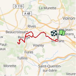
Moirans - monastère de parmenie

trailer38
User

Length
26 km

Max alt
729 m

Uphill gradient
825 m
Km-Effort
37 km

Min alt
198 m

Downhill gradient
824 m
Boucle
Yes
Creation date :
2015-08-19 00:00:00.0
Updated on :
2015-08-19 00:00:00.0
3h32
Difficulty : Medium

FREE GPS app for hiking
 SityTrail
IGN / Geographical institutes
SityTrail Plus
The world is yours!
About
Trail Running of 26 km to be discovered at Auvergne-Rhône-Alpes, Isère, Moirans. This trail is proposed by trailer38.
Positioning
Country:
France
Region :
Auvergne-Rhône-Alpes
Department/Province :
Isère
Municipality :
Moirans
Location:
Unknown
Start:(Dec)
Start:(UTM)
701124 ; 5022655 (31T) N.
Comments