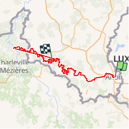
Trail Walking Arlon - gr16 - Photo
 B0uille
B0uille

User

© OpenStreetMap contributors
Length
Length
249 km
Max alt
Max alt
450 m
Uphill gradient
Uphill gradient
7626 m
Km-Effort
Km-Effort  
350 km
Min alt
Min alt
138 m
Downhill gradient
Downhill gradient
7661 m
Boucle
Boucle
No
Creation date :
2015-08-29 00:00:00.0
Updated on :
2015-08-29 00:00:00.0

(1 Reviews)

Walking
Walking
--
Difficulty : Medium

Scan this QR Code to open this trail in the SityTrail application

FREE GPS app for hiking

Logo SityTrail SityTrail

IGN / Geographical institutes

Download SityTrail from the App Store Download SityTrail from Google Play

Logo SityTrail SityTrail Plus

The world is yours!

Download SityTrail from the App Store Download SityTrail from Google Play Download SityTrail on Huawei AppGallery

About

Trail Walking of 249 km to be discovered at Wallonia, Luxembourg, Arlon. This trail is proposed by B0uille.

Elevation profile

Points of interest

Point of interest Vresse-sur-Semois - GR16 km172 Alle (Au Roy de la Bière) - Photo
B0uille
Point of interest Vresse-sur-Semois - GR16 km180 Vresse sur Semois (Maison du Toerisme) - Photo
B0uille
Point of interest Vresse-sur-Semois - GR16 km188 Bohan (Le Petit Chaudron) - Photo
B0uille

Positioning

Country:
Belgium
Region :
Wallonia
Department/Province :
Luxembourg
Municipality :
Arlon
Location:
Arlon
Start:(UTM)
703438 ; 5507051 (31U) N.

Comments

Please log in to post a review or rate the element


Close
My subscriptions