


Chaumont en Vexin, Chambors, Trie-Château

Marie-Claire-mcp
User
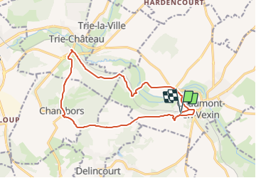

Length
14.7 km

Max alt
143 m

Uphill gradient
274 m
Km-Effort
18.4 km

Min alt
60 m

Downhill gradient
276 m
Boucle
Yes
Creation date :
2015-09-01 00:00:00.0
Updated on :
2015-09-01 00:00:00.0
3h58
Difficulty : Medium

FREE GPS app for hiking
 SityTrail
IGN / Geographical institutes
SityTrail Plus
The world is yours!
About
Trail Walking of 14.7 km to be discovered at Hauts-de-France, Oise, Chaumont-en-Vexin. This trail is proposed by Marie-Claire-mcp.
Positioning
Country:
France
Region :
Hauts-de-France
Department/Province :
Oise
Municipality :
Chaumont-en-Vexin
Location:
Unknown
Start:(Dec)
Start:(UTM)
417963 ; 5457113 (31U) N.
Comments