


Arrènes-Chatelus-Séjoux-St-Goussaud

csy95
User
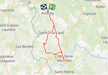

Length
26 km

Max alt
693 m

Uphill gradient
792 m
Km-Effort
37 km

Min alt
341 m

Downhill gradient
792 m
Boucle
Yes
Creation date :
2018-08-26 10:57:52.297
Updated on :
2018-08-26 10:57:52.33
7h39
Difficulty : Difficult

FREE GPS app for hiking
 SityTrail
IGN / Geographical institutes
SityTrail Plus
The world is yours!
About
Trail Walking of 26 km to be discovered at New Aquitaine, Creuse, Arrènes. This trail is proposed by csy95.
Description
Un grand tour avec pique-nique à la plage de Chatelus
Positioning
Country:
France
Region :
New Aquitaine
Department/Province :
Creuse
Municipality :
Arrènes
Location:
Unknown
Start:(Dec)
Start:(UTM)
389433 ; 5102943 (31T) N.
Comments