


J3 GR5 Bert

raphael94
User
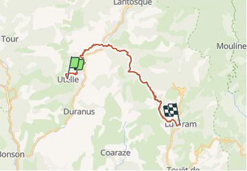

Length
22 km

Max alt
1132 m

Uphill gradient
1081 m
Km-Effort
37 km

Min alt
336 m

Downhill gradient
1236 m
Boucle
No
Creation date :
2015-09-11 00:00:00.0
Updated on :
2015-09-11 00:00:00.0
7h51
Difficulty : Unknown

FREE GPS app for hiking
 SityTrail
IGN / Geographical institutes
SityTrail Plus
The world is yours!
About
Trail Walking of 22 km to be discovered at Provence-Alpes-Côte d'Azur, Maritime Alps, Utelle. This trail is proposed by raphael94.
Positioning
Country:
France
Region :
Provence-Alpes-Côte d'Azur
Department/Province :
Maritime Alps
Municipality :
Utelle
Location:
Unknown
Start:(Dec)
Start:(UTM)
359282 ; 4864171 (32T) N.
Comments