


2015-09-16 Rando Chalo-Saint-Mars

jchezlemas
User
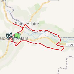

Length
7.6 km

Max alt
137 m

Uphill gradient
124 m
Km-Effort
9.3 km

Min alt
80 m

Downhill gradient
123 m
Boucle
Yes
Creation date :
2015-09-16 00:00:00.0
Updated on :
2015-09-16 00:00:00.0
--
Difficulty : Easy

FREE GPS app for hiking
 SityTrail
IGN / Geographical institutes
SityTrail Plus
The world is yours!
About
Trail Walking of 7.6 km to be discovered at Ile-de-France, Essonne, Chalo-Saint-Mars. This trail is proposed by jchezlemas.
Positioning
Country:
France
Region :
Ile-de-France
Department/Province :
Essonne
Municipality :
Chalo-Saint-Mars
Location:
Unknown
Start:(Dec)
Start:(UTM)
431071 ; 5364101 (31U) N.
Comments