


La Pointe Noire de Pormenaz - 2

bourel.jacques
User

Length
13.7 km

Max alt
2304 m

Uphill gradient
1077 m
Km-Effort
28 km

Min alt
1278 m

Downhill gradient
1078 m
Boucle
Yes
Creation date :
2015-10-02 00:00:00.0
Updated on :
2015-10-02 00:00:00.0
5h32
Difficulty : Difficult

FREE GPS app for hiking
 SityTrail
IGN / Geographical institutes
SityTrail Plus
The world is yours!
About
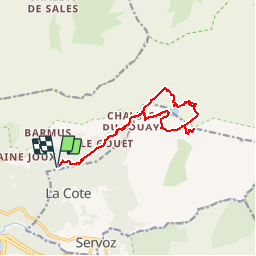
Trail Walking of 13.7 km to be discovered at Auvergne-Rhône-Alpes, Upper Savoy, Passy. This trail is proposed by bourel.jacques.
Description
La Pointe Noire de Pormenaz en partant du Lac Vert
Positioning
Country:
France
Region :
Auvergne-Rhône-Alpes
Department/Province :
Upper Savoy
Municipality :
Passy
Location:
Unknown
Start:(Dec)
Start:(UTM)
325910 ; 5090815 (32T) N.
Comments