


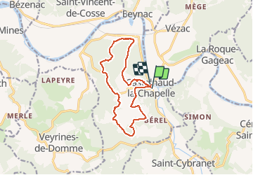
Boucle de Castelnaud

amelie14
User

Length
13.3 km

Max alt
238 m

Uphill gradient
414 m
Km-Effort
18.8 km

Min alt
75 m

Downhill gradient
411 m
Boucle
Yes
Creation date :
2018-07-09 20:22:23.053
Updated on :
2018-07-09 20:22:23.053
3h24
Difficulty : Unknown

FREE GPS app for hiking
 SityTrail
IGN / Geographical institutes
SityTrail Plus
The world is yours!
About
Trail Other activity of 13.3 km to be discovered at New Aquitaine, Dordogne, Castelnaud-la-Chapelle. This trail is proposed by amelie14.
Positioning
Country:
France
Region :
New Aquitaine
Department/Province :
Dordogne
Municipality :
Castelnaud-la-Chapelle
Location:
Unknown
Start:(Dec)
Start:(UTM)
353827 ; 4963899 (31T) N.
Comments