


les clots- sentier péronnard -pas de l'oeille

maupassant38
User
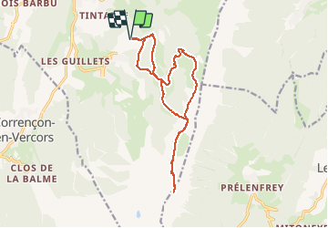

Length
15.8 km

Max alt
1959 m

Uphill gradient
867 m
Km-Effort
27 km

Min alt
1234 m

Downhill gradient
866 m
Boucle
Yes
Creation date :
2019-02-22 22:31:22.801
Updated on :
2019-02-22 22:31:22.817
5h35
Difficulty : Medium

FREE GPS app for hiking
 SityTrail
IGN / Geographical institutes
SityTrail Plus
The world is yours!
About
Trail Walking of 15.8 km to be discovered at Auvergne-Rhône-Alpes, Isère, Villard-de-Lans. This trail is proposed by maupassant38.
Positioning
Country:
France
Region :
Auvergne-Rhône-Alpes
Department/Province :
Isère
Municipality :
Villard-de-Lans
Location:
Unknown
Start:(Dec)
Start:(UTM)
702176 ; 4992381 (31T) N.
Comments