


aulp du seuil l alpe

cocosteph
User
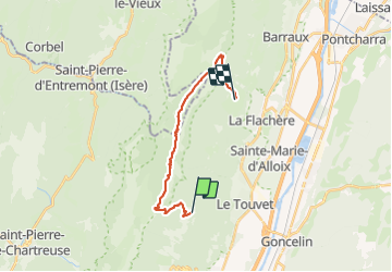

Length
17.6 km

Max alt
1893 m

Uphill gradient
1223 m
Km-Effort
34 km

Min alt
928 m

Downhill gradient
1364 m
Boucle
No
Creation date :
2015-10-01 00:00:00.0
Updated on :
2015-10-01 00:00:00.0
6h48
Difficulty : Unknown

FREE GPS app for hiking
 SityTrail
IGN / Geographical institutes
SityTrail Plus
The world is yours!
About
Trail Other activity of 17.6 km to be discovered at Auvergne-Rhône-Alpes, Isère, Plateau-des-Petites-Roches. This trail is proposed by cocosteph.
Positioning
Country:
France
Region :
Auvergne-Rhône-Alpes
Department/Province :
Isère
Municipality :
Plateau-des-Petites-Roches
Location:
Saint-Bernard
Start:(Dec)
Start:(UTM)
728614 ; 5026558 (31T) N.
Comments