


Mont de la Coche

whisper73
User
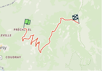

Length
7.3 km

Max alt
2045 m

Uphill gradient
1062 m
Km-Effort
18 km

Min alt
987 m

Downhill gradient
10 m
Boucle
No
Creation date :
2016-09-19 00:00:00.0
Updated on :
2016-09-19 00:00:00.0
2h17
Difficulty : Medium

FREE GPS app for hiking
 SityTrail
IGN / Geographical institutes
SityTrail Plus
The world is yours!
About
Trail Walking of 7.3 km to be discovered at Auvergne-Rhône-Alpes, Savoy, Jarsy. This trail is proposed by whisper73.
Positioning
Country:
France
Region :
Auvergne-Rhône-Alpes
Department/Province :
Savoy
Municipality :
Jarsy
Location:
Unknown
Start:(Dec)
Start:(UTM)
281224 ; 5060654 (32T) N.
Comments