


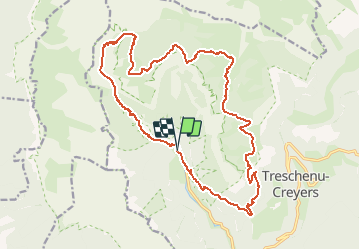
Vercors - Archiane - Cirque par les crêtes 21km D+1260m

manumax
User

Length
21 km

Max alt
1811 m

Uphill gradient
1268 m
Km-Effort
38 km

Min alt
742 m

Downhill gradient
1273 m
Boucle
Yes
Creation date :
2016-08-22 00:00:00.0
Updated on :
2020-05-23 21:06:31.243
7h55
Difficulty : Very difficult

FREE GPS app for hiking
 SityTrail
IGN / Geographical institutes
SityTrail Plus
The world is yours!
About
Trail Walking of 21 km to be discovered at Auvergne-Rhône-Alpes, Drôme, Châtillon-en-Diois. This trail is proposed by manumax.
Description
Randonnée Cirque d'Archiane
Positioning
Country:
France
Region :
Auvergne-Rhône-Alpes
Department/Province :
Drôme
Municipality :
Châtillon-en-Diois
Location:
Treschenu-Creyers
Start:(Dec)
Start:(UTM)
698450 ; 4957720 (31T) N.
Comments