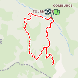
La Pointe d'Orcières (Par la Gutary)

bourel.jacques
User

Length
10.1 km

Max alt
1739 m

Uphill gradient
773 m
Km-Effort
20 km

Min alt
959 m

Downhill gradient
775 m
Boucle
Yes
Creation date :
2016-03-09 00:00:00.0
Updated on :
2016-03-09 00:00:00.0
4h12
Difficulty : Medium

FREE GPS app for hiking
 SityTrail
IGN / Geographical institutes
SityTrail Plus
The world is yours!
About
Trail Snowshoes of 10.1 km to be discovered at Auvergne-Rhône-Alpes, Upper Savoy, Manigod. This trail is proposed by bourel.jacques.
Positioning
Country:
France
Region :
Auvergne-Rhône-Alpes
Department/Province :
Upper Savoy
Municipality :
Manigod
Location:
Unknown
Start:(Dec)
Start:(UTM)
298569 ; 5080242 (32T) N.
Comments