


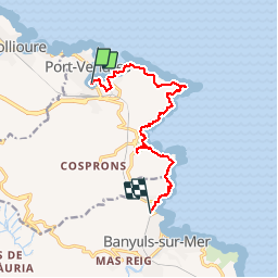
PORT VENDRES-BANYULS

CANON2
User

Length
11.3 km

Max alt
112 m

Uphill gradient
283 m
Km-Effort
15.1 km

Min alt
0 m

Downhill gradient
275 m
Boucle
No
Creation date :
2019-05-15 13:08:25.548
Updated on :
2019-05-15 13:08:25.684
3h21
Difficulty : Medium

FREE GPS app for hiking
 SityTrail
IGN / Geographical institutes
SityTrail Plus
The world is yours!
About
Trail Walking of 11.3 km to be discovered at Occitania, Pyrénées-Orientales, Port-Vendres. This trail is proposed by CANON2.
Positioning
Country:
France
Region :
Occitania
Department/Province :
Pyrénées-Orientales
Municipality :
Port-Vendres
Location:
Unknown
Start:(Dec)
Start:(UTM)
508809 ; 4707124 (31T) N.
Comments