


troyesFrancis

norihtom
User
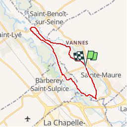

Length
11.4 km

Max alt
105 m

Uphill gradient
64 m
Km-Effort
12.3 km

Min alt
92 m

Downhill gradient
63 m
Boucle
Yes
Creation date :
2015-10-29 00:00:00.0
Updated on :
2015-10-29 00:00:00.0
2h43
Difficulty : Unknown

FREE GPS app for hiking
 SityTrail
IGN / Geographical institutes
SityTrail Plus
The world is yours!
About
Trail Walking of 11.4 km to be discovered at Grand Est, Aube, Sainte-Maure. This trail is proposed by norihtom.
Positioning
Country:
France
Region :
Grand Est
Department/Province :
Aube
Municipality :
Sainte-Maure
Location:
Unknown
Start:(Dec)
Start:(UTM)
578245 ; 5355334 (31U) N.
Comments
je découvre et ça me séduit vraiment!