


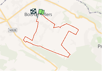
Boucle 8,2 KM Bois de Villers ( TAM)

warnant
User

Length
8.2 km

Max alt
267 m

Uphill gradient
82 m
Km-Effort
9.3 km

Min alt
233 m

Downhill gradient
84 m
Boucle
Yes
Creation date :
2015-11-01 00:00:00.0
Updated on :
2015-11-01 00:00:00.0
1h00
Difficulty : Unknown

FREE GPS app for hiking
 SityTrail
IGN / Geographical institutes
SityTrail Plus
The world is yours!
About
Trail Other activity of 8.2 km to be discovered at Wallonia, Namur, Profondeville. This trail is proposed by warnant.
Positioning
Country:
Belgium
Region :
Wallonia
Department/Province :
Namur
Municipality :
Profondeville
Location:
Bois-de-Villers
Start:(Dec)
Start:(UTM)
629583 ; 5583406 (31U) N.
Comments