


dimanche

theo89
User

Length
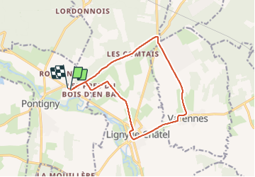
13.5 km

Max alt
183 m

Uphill gradient
153 m
Km-Effort
15.6 km

Min alt
108 m

Downhill gradient
152 m
Boucle
Yes
Creation date :
2015-11-01 00:00:00.0
Updated on :
2015-11-01 00:00:00.0
2h31
Difficulty : Very easy

FREE GPS app for hiking
 SityTrail
IGN / Geographical institutes
SityTrail Plus
The world is yours!
About
Trail Walking of 13.5 km to be discovered at Bourgogne-Franche-Comté, Yonne, Pontigny. This trail is proposed by theo89.
Positioning
Country:
France
Region :
Bourgogne-Franche-Comté
Department/Province :
Yonne
Municipality :
Pontigny
Location:
Unknown
Start:(Dec)
Start:(UTM)
554239 ; 5307088 (31T) N.
Comments