


L'ETANG DU MARQUIS

COMAN
User
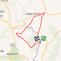

Length
6.2 km

Max alt
901 m

Uphill gradient
128 m
Km-Effort
7.9 km

Min alt
832 m

Downhill gradient
128 m
Boucle
Yes
Creation date :
2015-11-01 00:00:00.0
Updated on :
2015-11-01 00:00:00.0
1h39
Difficulty : Very easy

FREE GPS app for hiking
 SityTrail
IGN / Geographical institutes
SityTrail Plus
The world is yours!
About
Trail Walking of 6.2 km to be discovered at Auvergne-Rhône-Alpes, Upper Savoy, Fillière. This trail is proposed by COMAN.
Description
Réserve naturelle
Positioning
Country:
France
Region :
Auvergne-Rhône-Alpes
Department/Province :
Upper Savoy
Municipality :
Fillière
Location:
Évires
Start:(Dec)
Start:(UTM)
283767 ; 5102019 (32T) N.
Comments