


20151108 La Charmille

xtof_ts
User
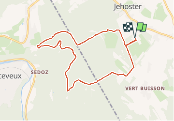

Length
9 km

Max alt
419 m

Uphill gradient
191 m
Km-Effort
11.6 km

Min alt
271 m

Downhill gradient
191 m
Boucle
Yes
Creation date :
2015-11-30 00:00:00.0
Updated on :
2015-11-30 00:00:00.0
2h41
Difficulty : Medium

FREE GPS app for hiking
 SityTrail
IGN / Geographical institutes
SityTrail Plus
The world is yours!
About
Trail Other activity of 9 km to be discovered at Wallonia, Liège, Theux. This trail is proposed by xtof_ts.
Positioning
Country:
Belgium
Region :
Wallonia
Department/Province :
Liège
Municipality :
Theux
Location:
La Reid
Start:(Dec)
Start:(UTM)
697210 ; 5595156 (31U) N.
Comments
bien