


Le Vallon de Carlaveyron

bourel.jacques
User
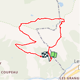

Length
10 km

Max alt
2276 m

Uphill gradient
873 m
Km-Effort
22 km

Min alt
1442 m

Downhill gradient
873 m
Boucle
Yes
Creation date :
2016-09-30 00:00:00.0
Updated on :
2016-09-30 00:00:00.0
4h22
Difficulty : Medium

FREE GPS app for hiking
 SityTrail
IGN / Geographical institutes
SityTrail Plus
The world is yours!
About
Trail Walking of 10 km to be discovered at Auvergne-Rhône-Alpes, Upper Savoy, Les Houches. This trail is proposed by bourel.jacques.
Positioning
Country:
France
Region :
Auvergne-Rhône-Alpes
Department/Province :
Upper Savoy
Municipality :
Les Houches
Location:
Unknown
Start:(Dec)
Start:(UTM)
331004 ; 5086020 (32T) N.
Comments