Trail Mountain bike Évreux - Ouest_sud-ouest Evreux - Photo

Ouest_sud-ouest Evreux

© OpenStreetMap contributors
Length
Length
30 km
Max alt
Max alt
168 m
Uphill gradient
Uphill gradient
373 m
Km-Effort
Km-Effort  
35 km
Min alt
Min alt
66 m
Downhill gradient
Downhill gradient
350 m
Boucle
Boucle
No
Creation date :
2015-11-15 00:00:00.0
Updated on :
2015-11-15 00:00:00.0

(0 Reviews)

Mountain bike
Mountain bike
2h28
Difficulty : Easy

Scan this QR Code to open this trail in the SityTrail application

FREE GPS app for hiking

Logo SityTrail SityTrail

IGN / Geographical institutes

Download SityTrail from the App Store Download SityTrail from Google Play

Logo SityTrail SityTrail Plus

The world is yours!

Download SityTrail from the App Store Download SityTrail from Google Play Download SityTrail on Huawei AppGallery

About

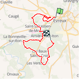
Trail Mountain bike of 30 km to be discovered at Normandy, Eure, Évreux. This trail is proposed by fredtruc27.

Description

découvrez le cimetière de l'HP où les malades sans famille, ainsi qu'un médecin ont été enterré, ainsi que le terrain de tennis et le kiosque sur les hauteurs de l'hôpital. Traversée de st Sébastien par des chemins de traverse avec arrivée sur le point de vue sur Arnières avant d'y descendre et remonter par le cimetière d'Arnières pour traverser la forêt jusqu'en haut d'Aulnays.
On rejoint ensuite les Baux Ste Croix, puis retour à Evreux

Elevation profile

Positioning

Country:
France
Region :
Normandy
Department/Province :
Eure
Municipality :
Évreux
Location:
Unknown
Start:(UTM)
363126 ; 5431549 (31U) N.


Close
My subscriptions