


mont servoz - lac vert

fredtruc27
User
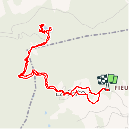

Length
6.9 km

Max alt
1294 m

Uphill gradient
305 m
Km-Effort
11 km

Min alt
996 m

Downhill gradient
307 m
Boucle
Yes
Creation date :
2015-11-15 00:00:00.0
Updated on :
2015-11-15 00:00:00.0
1h58
Difficulty : Easy

FREE GPS app for hiking
 SityTrail
IGN / Geographical institutes
SityTrail Plus
The world is yours!
About
Trail Walking of 6.9 km to be discovered at Auvergne-Rhône-Alpes, Upper Savoy, Servoz. This trail is proposed by fredtruc27.
Positioning
Country:
France
Region :
Auvergne-Rhône-Alpes
Department/Province :
Upper Savoy
Municipality :
Servoz
Location:
Unknown
Start:(Dec)
Start:(UTM)
326638 ; 5090131 (32T) N.
Comments