34-Azillanet : La Ramière-16/11/2015*

Jovila
User
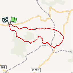

Length
7.6 km

Max alt
208 m

Uphill gradient
155 m
Km-Effort
9.7 km

Min alt
101 m

Downhill gradient
155 m
Boucle
Yes
Creation date :
2016-04-21 00:00:00.0
Updated on :
2016-04-21 00:00:00.0
1h52
Difficulty : Easy

FREE GPS app for hiking
 SityTrail
IGN / Geographical institutes
SityTrail Plus
The world is yours!
About
Trail Walking of 7.6 km to be discovered at Occitania, Hérault, Azillanet. This trail is proposed by Jovila.
Positioning
Country:
France
Region :
Occitania
Department/Province :
Hérault
Municipality :
Azillanet
Location:
Unknown
Start:(Dec)
Start:(UTM)
479742 ; 4796841 (31T) N.
Comments