


Le Crépon de Montoulivert

bourel.jacques
User
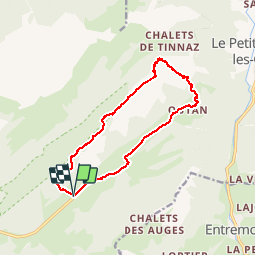

Length
14.9 km

Max alt
1903 m

Uphill gradient
610 m
Km-Effort
23 km

Min alt
1361 m

Downhill gradient
610 m
Boucle
Yes
Creation date :
2015-11-17 00:00:00.0
Updated on :
2015-11-17 00:00:00.0
4h55
Difficulty : Medium

FREE GPS app for hiking
 SityTrail
IGN / Geographical institutes
SityTrail Plus
The world is yours!
About
Trail Walking of 14.9 km to be discovered at Auvergne-Rhône-Alpes, Upper Savoy, Fillière. This trail is proposed by bourel.jacques.
Positioning
Country:
France
Region :
Auvergne-Rhône-Alpes
Department/Province :
Upper Savoy
Municipality :
Fillière
Location:
Thorens-Glières
Start:(Dec)
Start:(UTM)
293263 ; 5093792 (32T) N.
Comments
difficulté : plutôt difficile, escalade et terrain accidenté
tres bien fait . va etre utile pour randonner