


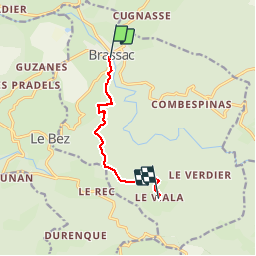
GRP Brassac le Viala

CANON2
User

Length
7.1 km

Max alt
804 m

Uphill gradient
387 m
Km-Effort
11.3 km

Min alt
491 m

Downhill gradient
110 m
Boucle
No
Creation date :
2019-05-15 13:08:23.728
Updated on :
2019-05-15 13:08:23.87
2h30
Difficulty : Medium

FREE GPS app for hiking
 SityTrail
IGN / Geographical institutes
SityTrail Plus
The world is yours!
About
Trail Walking of 7.1 km to be discovered at Occitania, Tarn, Brassac. This trail is proposed by CANON2.
Positioning
Country:
France
Region :
Occitania
Department/Province :
Tarn
Municipality :
Brassac
Location:
Unknown
Start:(Dec)
Start:(UTM)
459427 ; 4830753 (31T) N.
Comments