


le oas de la pierre

raygautier
User
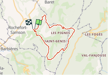

Length
16.6 km

Max alt
1146 m

Uphill gradient
1026 m
Km-Effort
30 km

Min alt
417 m

Downhill gradient
1019 m
Boucle
Yes
Creation date :
2015-11-20 00:00:00.0
Updated on :
2015-11-20 00:00:00.0
6h53
Difficulty : Unknown

FREE GPS app for hiking
 SityTrail
IGN / Geographical institutes
SityTrail Plus
The world is yours!
About
Trail Other activity of 16.6 km to be discovered at Auvergne-Rhône-Alpes, Drôme, Rochefort-Samson. This trail is proposed by raygautier.
Positioning
Country:
France
Region :
Auvergne-Rhône-Alpes
Department/Province :
Drôme
Municipality :
Rochefort-Samson
Location:
Unknown
Start:(Dec)
Start:(UTM)
671069 ; 4982165 (31T) N.
Comments