


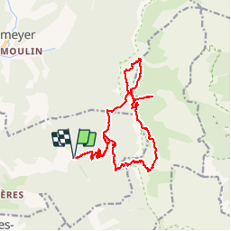
la vire du glandasse

raygautier
User

Length
21 km

Max alt
1987 m

Uphill gradient
2306 m
Km-Effort
52 km

Min alt
661 m

Downhill gradient
2305 m
Boucle
Yes
Creation date :
2015-11-20 00:00:00.0
Updated on :
2015-11-20 00:00:00.0
12h04
Difficulty : Unknown

FREE GPS app for hiking
 SityTrail
IGN / Geographical institutes
SityTrail Plus
The world is yours!
About
Trail Other activity of 21 km to be discovered at Auvergne-Rhône-Alpes, Drôme, Die. This trail is proposed by raygautier.
Positioning
Country:
France
Region :
Auvergne-Rhône-Alpes
Department/Province :
Drôme
Municipality :
Die
Location:
Unknown
Start:(Dec)
Start:(UTM)
692590 ; 4957539 (31T) N.
Comments