


tour de mise en jambe 6.5

cailloux54
User
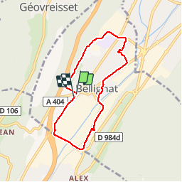

Length
6.5 km

Max alt
563 m

Uphill gradient
66 m
Km-Effort
7.4 km

Min alt
517 m

Downhill gradient
67 m
Boucle
Yes
Creation date :
2015-11-27 00:00:00.0
Updated on :
2015-11-27 00:00:00.0
1h25
Difficulty : Very easy

FREE GPS app for hiking
 SityTrail
IGN / Geographical institutes
SityTrail Plus
The world is yours!
About
Trail Walking of 6.5 km to be discovered at Auvergne-Rhône-Alpes, Ain, Bellignat. This trail is proposed by cailloux54.
Positioning
Country:
France
Region :
Auvergne-Rhône-Alpes
Department/Province :
Ain
Municipality :
Bellignat
Location:
Unknown
Start:(Dec)
Start:(UTM)
702334 ; 5124163 (31T) N.
Comments