


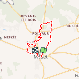
De Mettet à Pontaury par le hameau de Scry

Desrumaux
User GUIDE

Length
10.3 km

Max alt
289 m

Uphill gradient
155 m
Km-Effort
12.3 km

Min alt
207 m

Downhill gradient
152 m
Boucle
Yes
Creation date :
2014-12-10 00:00:00.0
Updated on :
2014-12-10 00:00:00.0
2h35
Difficulty : Easy

FREE GPS app for hiking
 SityTrail
IGN / Geographical institutes
SityTrail Plus
The world is yours!
About
Trail Walking of 10.3 km to be discovered at Wallonia, Namur, Mettet. This trail is proposed by Desrumaux.
Description
Details sur TraceGPS.com
http://www.tracegps.com/fr/parcours/circuit10817.htm#
Positioning
Country:
Belgium
Region :
Wallonia
Department/Province :
Namur
Municipality :
Mettet
Location:
Mettet
Start:(Dec)
Start:(UTM)
617967 ; 5575639 (31U) N.
Comments