


saint honorine du fay 10 kms

aubinjoel
User
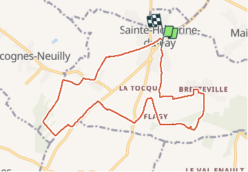

Length
9.9 km

Max alt
157 m

Uphill gradient
128 m
Km-Effort
11.6 km

Min alt
64 m

Downhill gradient
127 m
Boucle
No
Creation date :
2015-12-04 00:00:00.0
Updated on :
2015-12-04 00:00:00.0
--
Difficulty : Easy

FREE GPS app for hiking
 SityTrail
IGN / Geographical institutes
SityTrail Plus
The world is yours!
About
Trail Walking of 9.9 km to be discovered at Normandy, Calvados, Sainte-Honorine-du-Fay. This trail is proposed by aubinjoel.
Positioning
Country:
France
Region :
Normandy
Department/Province :
Calvados
Municipality :
Sainte-Honorine-du-Fay
Location:
Unknown
Start:(Dec)
Start:(UTM)
683108 ; 5438925 (30U) N.
Comments