


le luthier long

CANON2
User
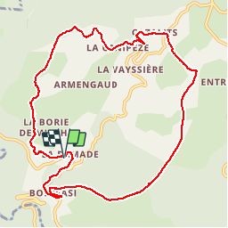

Length
11.7 km

Max alt
740 m

Uphill gradient
333 m
Km-Effort
16.1 km

Min alt
502 m

Downhill gradient
336 m
Boucle
Yes
Creation date :
2019-05-15 13:08:23.061
Updated on :
2019-05-15 13:08:23.273
3h12
Difficulty : Very easy

FREE GPS app for hiking
 SityTrail
IGN / Geographical institutes
SityTrail Plus
The world is yours!
About
Trail Walking of 11.7 km to be discovered at Occitania, Tarn, Fontrieu. This trail is proposed by CANON2.
Positioning
Country:
France
Region :
Occitania
Department/Province :
Tarn
Municipality :
Fontrieu
Location:
Ferrières
Start:(Dec)
Start:(UTM)
455514 ; 4834457 (31T) N.
Comments