


Quatre routes

Gegetop
User

Length
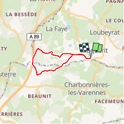
8.6 km

Max alt
856 m

Uphill gradient
208 m
Km-Effort
11.4 km

Min alt
673 m

Downhill gradient
209 m
Boucle
Yes
Creation date :
2015-12-08 00:00:00.0
Updated on :
2015-12-08 00:00:00.0
2h09
Difficulty : Easy

FREE GPS app for hiking
 SityTrail
IGN / Geographical institutes
SityTrail Plus
The world is yours!
About
Trail Walking of 8.6 km to be discovered at Auvergne-Rhône-Alpes, Puy-de-Dôme, Loubeyrat. This trail is proposed by Gegetop.
Description
balade
Positioning
Country:
France
Region :
Auvergne-Rhône-Alpes
Department/Province :
Puy-de-Dôme
Municipality :
Loubeyrat
Location:
Unknown
Start:(Dec)
Start:(UTM)
500117 ; 5085466 (31T) N.
Comments