


Les Fanges de l'abime et le camp du maquis

Desrumaux
User GUIDE

Length
11.8 km

Max alt
506 m

Uphill gradient
225 m
Km-Effort
14.9 km

Min alt
384 m

Downhill gradient
233 m
Boucle
Yes
Creation date :
2014-12-10 00:00:00.0
Updated on :
2014-12-10 00:00:00.0
3h00
Difficulty : Easy

FREE GPS app for hiking
 SityTrail
IGN / Geographical institutes
SityTrail Plus
The world is yours!
About
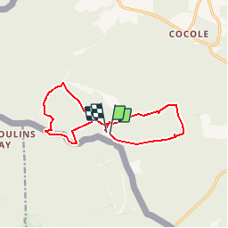
Trail Walking of 11.8 km to be discovered at Wallonia, Namur, Gedinne. This trail is proposed by Desrumaux.
Description
Details de la rando sur TraceGPS.com
http://www.tracegps.com/fr/parcours/circuit2608.htm
Positioning
Country:
Belgium
Region :
Wallonia
Department/Province :
Namur
Municipality :
Gedinne
Location:
Bourseigne-Neuve
Start:(Dec)
Start:(UTM)
632325 ; 5534898 (31U) N.
Comments