


Boucle St Gérard 7.9 km

warnant
User
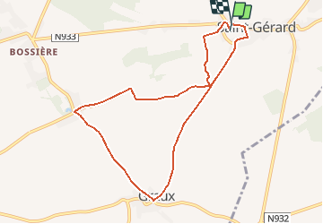

Length
7.9 km

Max alt
261 m

Uphill gradient
76 m
Km-Effort
8.9 km

Min alt
217 m

Downhill gradient
84 m
Boucle
Yes
Creation date :
2015-12-12 00:00:00.0
Updated on :
2015-12-12 00:00:00.0
1h00
Difficulty : Easy

FREE GPS app for hiking
 SityTrail
IGN / Geographical institutes
SityTrail Plus
The world is yours!
About
Trail Running of 7.9 km to be discovered at Wallonia, Namur, Mettet. This trail is proposed by warnant.
Positioning
Country:
Belgium
Region :
Wallonia
Department/Province :
Namur
Municipality :
Mettet
Location:
Saint-Gérard
Start:(Dec)
Start:(UTM)
623403 ; 5578538 (31U) N.
Comments